Bhavanisagar is a Town Panchayat and it is located in Sathyamangalam Taluk of Erode District. It is about 72 Kms north of Coimbatore and 80 Kms west of Erode and 35 Kms west of Gobichettipalayam and it is located 16 kms west of Sathyamangalam, 18 Kms north of Punjai Puliyampatti and 35 Kms north of Mettupalayam.
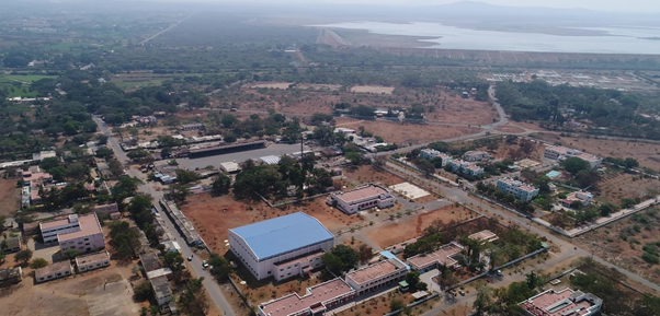
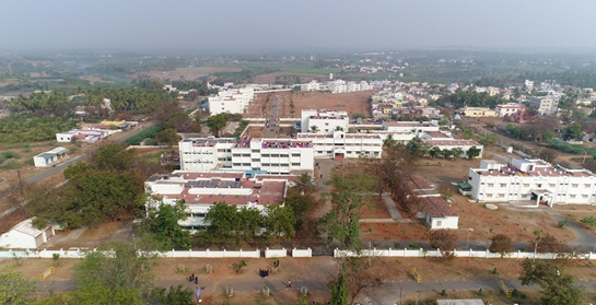
There is no rail connectivity to Bhavanisagar. The nearest railway stations are Mettupalayam ( 35 Kms. ), Thiruppur Jn. ( 50 Kms. ), Coimbatore Jn. ( 72 Kms. ) and Erode Jn. ( 80 Kms ).There are adequate bus connectivity from Erode, Gobichettipalayam, Sathyamangalam, Punjai Puliyampatti, Coimbatore, Thiruppur, Mettupalayam, etc.,The Institute is located in the heart of the Township, Bhavanisagar. It is just 200 Mtrs. from the Bus Stand.
Population of Bhavanisagar Town Panchayat is 4,329 (Male – 2,212 & Female – 2,117) and Bhavanisagar Panchayat Union is 72,240 (Male - 39,073 & Female – 36,949), as per 2011 Census. Total Population is 76,569 (41,285 males & 39,066 females).
Bhavanisagar forms part of the Sathyamangalam Reserve Forest. The Sathyamangalam RF was originally a part of the Nilgiris Eastern Slopes Reserve, which was declared as a Reserved Forest way back in 1886. The Sathyamangalam Reserve Forest spreads over an area of 1450 Sq. KM. Bhavanisagar Range falls within the jurisdiction of Sathyamangalam RF and it has 300 Sq. Km.
It borders the Erode District and Nilgiris District starts from 15th Km. There is a famous Tribal Settlement at Thengumarahada in Nilgiris. It is located at a distance of 45 Kms. from Bhavanisagar. Mangalapatti, a small habitat, located at a distance of 15 KMs from Bhavanisagar is the point where actually the Eastern Ghats and Western Ghats meet.
The Sathyamangalam RF along with Thalavadi is the constituent of Eastern slope of the Western Ghats, wherein we could observe the distribution of forests in to five distinct patterns, based on the altitude. They are, Sub Tropical Shrub Jungle, High Tropical Savannah, Dry Deciduous Forest, Moist Deciduous Forest and High Altitude Semi-Evergreen Forest, in the ascending altitude order.
Thengumarahada, in the foothills of the Nilgiris (located at a distance of 50 KM from Bhavanisagar) is one of the most famous preferred Breeding Grounds for the elephants in Western Ghats.
The area is very rich in flora and fauna. The common animals in these areas are, Tiger, Leopard, Sloth Bear, Barking Deer, Musk Deer, Spotter Deer, Four Horned Deer, Armadillo, Porcupine, Gaur, Nilghai Tahr, Jackal, Spotted Hyenah, Sambar Deer, Wild Pig, Wild Dog, Common Langur, Bonnel Macaque, etc., All the four types of Vultures are spotted here.
Bhavanisagar is infact a recovery forest, means the lost habitat is slowly rejuvenating. It forms part of the Nilgiris Biosphere Reserve (UNESCO) and the rich biodiversity of western Ghats can be observed here.
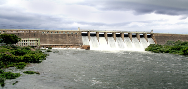
Bhavanisagar Dam and Reservoir, also called Lower Bhavani Dam, is located on the Bhavani River between Mettupalayam and Sathyamangalam in Erode District, Tamil Nadu, South India.
The dam is considered to be among the biggest earthen dam in the country. It is also the second biggest earthen dam in the World. The length of the earthen bund itself runs in to 8 Kms. from Zero Point. The Dam was constructed during post independent period from 1948 to 1955. The construction cost of the dam was 21.00 Crore. It is a Multi-Purpose Dam. It is used to store water for irrigation, generate electricity, supply drinking water, control flood and control the silt formation in the downstream river.
The Height of the Dam is 40 Mtrs. ( 120 Ft ) and the carrying capacity of the Dam is 32.8 TMC. The FRL ( Full Reservoir Level ) is 120 Ft. It forms the tail end of the long river chain on the eastern side of the Western Ghats in Nilgiris. The Dam receives water through Southwest Monsoon from two main streams/ catchment areas from the Western Ghats. One stream is from Upper Bhavani, Avalanche, Emerald, Kundha, Gedhai, Pillur, Nellithurai and Lower Bhavani ( Bhavanisagar ). The other stream called as Western Catchment starts from Portimund, Parson’s Valley, Pykara, Glenmorgan, Chinkara, Maravakandy, Moyar, Thengumarahatta and Lower Bhavani ( Bhavanisagar ).
Bhavani Sagar dam is constructed on Bhavani River, which is merely under the union of Moyar River. The dam is used to divert water to the Lower Bhavani Project Canal. The Dam houses two Hydel Power Stations one on the East Bank Canal and the other on the main Bhavani River. Each of the Units has 16 MW installed capacity. Thus, 32 MW of power is generated almost throughout the year. There is a garden in front of this dam, which makes it a good picnic spot in this area.